

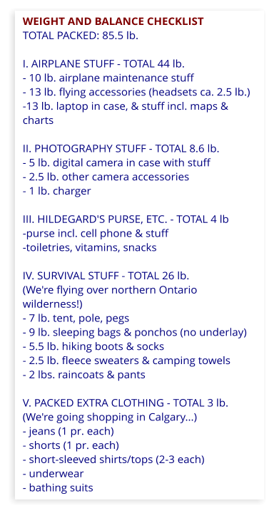
1) Flight Planning
At start-up, Werner listens to ATIS
(information, mainly weather
conditions) and jots it down in his
flight checklist on a clipboard on
his lap. Other flight data is added
enroute.
For example:


PILOT’S CLIPBOARD...
Detail:
Distance
Date
Start
Take-off
Landing
Stop
Air time
Flight time
ATIS:
Wind
Press
Ceiling
Visibility
Precipitation
Runway
CYKF-CYZE
323 km
174 nm
July 7
16:10
16:17
18:42
18:43
2.4 hr.
2.5 hr.
E
210/7
2986
1000
7
0
14
...AND WHAT IT MEANS:
Waterloo Regional Airport to Gore Bay Airport
Distance from airport to airport in kilometres
Distance in nautical miles (1 nm = 1.852 km)
Started engine at 4:10 p.m.
Actual take-off at 4:17 p.m.
Touched down at 6:42 p.m.
Engine turned off at 6:43 p.m.
Time from take-off to landing
Time from start to stop
A.T. Information Service - See Explanations.
From SW (210 degrees), 7 nm per hour (7 knots)
Air pressure: 29.86 inches of mercury
Cloud layer at 1000 ft. above ground
You can see as far as 7 nautical miles
Not raining (or snowing...)
Runway to be used at departure: 14.
See Explanations.

Waterloo to Calgary in a Cessna 150


Using maps, GPS, computers, book
Important notice: All images and text on this website ©whphotoplus. All rights reserved. You view this website at your own risk.
External links are provided for information only; each opens in a new window. We take no responsibility for their content or your usage of those websites.
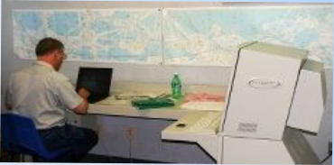
Flight Planning 2003: Using a modern computer!
Extra! Pilot Stuff